About vTools Survey - GPS Mapping
Function of application: - Positioning, current position, practical view angle in the field. Help identify better directions. - Allows users to directly create objects (Points, Lines, Polygons, Coordinate Waypoints,...
Function of application:
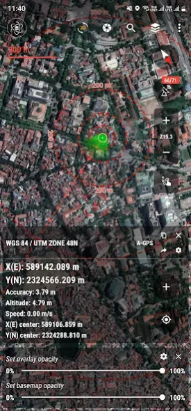
- Positioning, current position, practical view angle in the field. Help identify better directions.
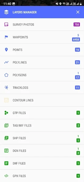
- Allows users to directly create objects (Points, Lines, Polygons, Coordinate Waypoints, Tracklog routes).
- Allows rapid measurement of the area and length of objects in the field.
- Users can simultaneously create Tracklog, Point, Line, and Polygon at the same time while moving. Tracklog mode allows running in the background.
- Support to save attribute information and images in the field.
- Users can define forms fields to collect. And share quickly to the whole group via QR code or export to file.
- Find for waypoint, enter a list of waypoints from data TEXT(*.txt), Excel (*.xls, *.xlsx), CSV (*.csv) Excel and convert point coordinates directly on the device.
- Allow to enter the list of points to check by hand (For example, it is necessary to check the location of the extract of the red book).
- Support directly opening common data such as Excel, GPS/GPX, KML/KMZ, GeoJSON, AutoCAD DXF, MicroStation DGN, ESRI Shapefile SHP, MapInfo TAB, gCadas GTP, GeoTIFF, JPG, PNG
- Support export data to GPX, KML, GeoJSON, Excel, AutoCAD DXF, MapInfo TAB, Shapefile SHP format and share via Email, Drive, Zalo, Facebook etc.
- Fully support the VN 2000 projection system of the local and nationwide of Vietnam.
- Support more than 5000 projection systems of other countries and territories in the world.
- Support for old projection systems like Hanoi 1972 (HN 72).
- Support numerical compass feature
- Support reading offline map data MBTiles and intelligent management of data layers.
- Support with simple MBTiles convert tool on Desktop, help to view properties directly from MBTiles layer.
- Support conversion of TCVN3, VNI encoding for Vietnamese font in viewing attribute information.
- Support field photography, save location, shooting direction on images and Exif information, GeoTag
- Allow users to download Google, MapBox, Bing, ESRI, OSM directly on the computer for offline use.
- Support web map service TMS and WMS.
- The feature allows users to directly find and use Landsat 8 satellite image data (16-day update cycle) and Sentinel 2 (5-day update cycle) from the image database.
- Location view feature with 3D perspective with global elevation digital model.
If you need assistance please contact us at the following information:
Facebook: https://www.facebook.com/vToolsForMapInfo
Email:
[email protected]
Phone (Zalo, WhatsApp, Viber, Telegram): (+84) 96 990 4596
Website: https://apps.vtools.xyz
Youtube: https://www.youtube.com/c/vTools/playlists
All Rights Reserved. Copyright © vTools Apps
Previous Versions
Here you can find the changelog of vTools Survey - GPS Mapping since it was posted on our website on 2022-03-15 08:02:16.
The latest version is 7.2.9 and it was updated on 2024-04-27 17:23:16. See below the changes in each version.
vTools Survey - GPS Mapping version 7.2.9
Updated At: 2024-04-20
Changes: Updated version v7.2.9
- Updated libs core and optimization app
vTools Survey - GPS Mapping version 7.2.7
Updated At: 2024-03-25
Changes: Updated version v7.2.7
- Bug fixes and application optimization
vTools Survey - GPS Mapping version 7.2.7
Updated At: 2024-03-25
vTools Survey - GPS Mapping version 7.2.2
Updated At: 2024-02-21
Changes: Release version v7.2.2
- Set the default no fill area when exporting KML files
- Added 3D drawing and Elevation Median calculation function.
vTools Survey - GPS Mapping version 7.2.0
Updated At: 2024-01-30
Changes: Release version v7.2.0
- Optimize Location Manager
vTools Survey - GPS Mapping version 7.1.5
Updated At: 2024-01-14
Changes: Release version v7.1.5
- Fix bugs
vTools Survey - GPS Mapping version 7.1.2
Updated At: 2024-01-02
Changes: Release version v7.1.2
- Optimized GPS module processing and compatibility with more types of devices.
- Fix some errors and optimize the system.
vTools Survey - GPS Mapping version 7.1.0
Updated At: 2023-12-20
Changes: Release version v7.1.0
- Accelerate processing and optimize applications.
vTools Survey - GPS Mapping version 7.0.8
Updated At: 2023-12-02
Changes: Release version v7.0.8
- Upgrade to Android 14 - Upside Down Cake
- Update core libs.
vTools Survey - GPS Mapping version 7.0.5
Updated At: 2023-10-31
Changes: Release version v7.0.5
- Upgrade to Android 14 - Upside Down Cake (BETA).
- Support opening KML/KMZ and GPX data on 3D terrain.
- Optimization and bug fixes.
Disclaimer
Official Google Play Link
We do not host vTools Survey - GPS Mapping on our servers. We did not scan it for viruses, adware, spyware or other type of malware. This app is hosted by Google and passed their terms and conditions to be listed there. We recommend caution when installing it.
The Google Play link for vTools Survey - GPS Mapping is provided to you by apps112.com without any warranties, representations or guarantees of any kind, so access it at your own risk.
If you have questions regarding this particular app contact the publisher directly. For questions about the functionalities of apps112.com contact us.